



While gathering information for my research project, I found myself deep in the world of geographic information systems (GIS): datasets, shapefiles, layers, and spatial analysis. I began building a map inventory for my study area, treating each dataset as another piece of the landscape, and slowly, I began to think that the more information I could put on a map, the better I would understand the place.
After weeks of building this map inventory, I decided to show my work to my father. He is an architect by profession but has also lived in the city for almost 50 years, so I was curious to hear what he thought. I walked him through my research and the different maps, explaining how I had overlaid different datasets, identified recurring patterns, and analyzed the missing pieces that needed to be worked on. I was excited by how many gaps were being revealed.
Then he said something very simple:
A map can tell us a great deal about a place, but it can never tell us the whole story.
That sentence stopped me in my tracks.
Until then, I had approached GIS with a purely technical skill: creating layers, collecting datasets, and producing maps. But after that conversation, I started seeing GIS as something completely different. It was no longer simply a technical tool; instead, it became an instrument for paying attention.
A map can show us patterns. For instance, it can show concentrations of development, paved surfaces, sparse tree canopy, or limited access to parks. When these layers are combined with information about income, housing, and demographics, patterns of environmental and social vulnerability become much more visible. But they still cannot tell us what it feels like to live there.
It cannot tell us that a small patch of shade might be the only comfortable place to sit under on a hot afternoon, or that a park that appears geographically accessible on the surface may not truly feel inclusive and safe for everyone. And it certainly cannot convey the memories, routines, relationships, and sense of belonging that people develop with a place. That realization changed the way I understood impact assessment.
Environmental impacts are often discussed as if they affect everyone equally. In reality, the experience of a city can be dramatically different from one neighbourhood to another. (See below for example)
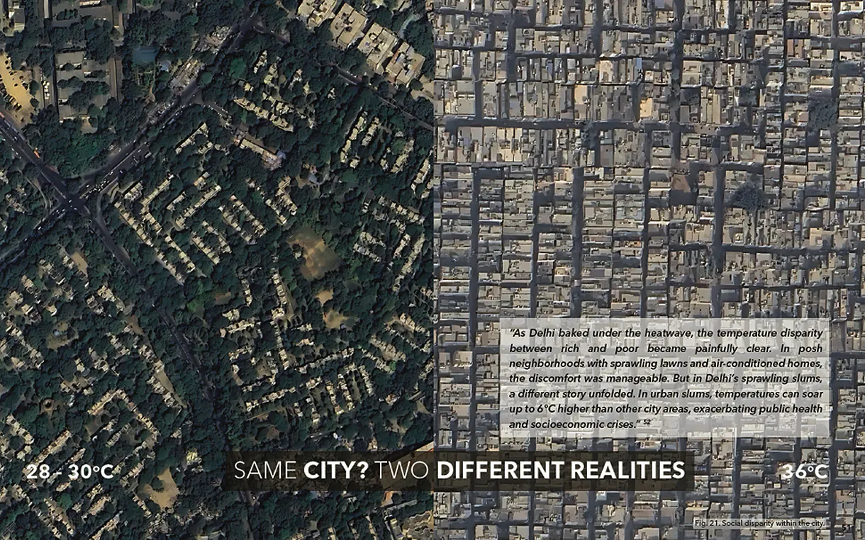
Social disparity within the city. Source: Mehta k. (2025), “Green Equity: designing heat-resilient public spaces for Delhi,” Fig. 21.
GIS can help us identify where these conditions overlap. It can help us visually see the areas where further attention is needed. But I also learned that identifying vulnerability is not the same as understanding it.
Data can tell us where we should begin; but it is the people who help us understand what we are actually looking at. Field observation can reveal something the dataset missed. A conversation with a resident can challenge an assumption initially made from studying a map. A space that appears underused on a map might actually be an important gathering place.
The reality of a place is often much richer, and more complex, than what appears on a screen.
This is where I see the role of landscape architecture becoming particularly important. We work somewhere between data and experience, systems and people, analysis and design. GIS can help us understand the larger systems shaping a landscape, but our responsibility is not simply to respond to what the map tells us; we need to question it, ground it in lived experience, and understand the unique systems behind what we are seeing.
I now see GIS, community engagement, field observation, ecological knowledge, and design as interconnected ways of understanding a place. A spatial analysis might identify a priority area, but being there might reveal something the data missed. A conversation with a resident has the possibility of changing our entire understanding of the problem, and ecological knowledge may tell us what is possible. Together, these insights can lead to a design response that is more thoughtful and appropriate to the people and landscape it serves.
This experience has also changed the way I think about the role of a landscape designer: good design does not necessarily begin with a solution; it begins with paying attention.
GIS helps us see patterns, and community engagement helps us understand them.
Impact assessment helps us recognize their consequences, and good landscape design gives us the opportunity to respond. Maps may show us where something is happening, but it is the people who live there who can help us truly understand what it means. And perhaps that is the most important lesson I took away from my practicum: as landscape designers, our job is not to simply make “better maps” or “better designs.” It is to develop a deeper understanding of the places we are working in and to make sure that the people who experience those places every day are not lost somewhere between the layers.